The flight of Shenzhou
Orbital
data
This analysis is based on a
sorting of available orbital data by Geoff Perry. He succeeded in
determining how Space Command had change catalog numbers and international
designators for all the objects resulting from the launch.
The initial orbit of Shenzhou
was 196.3-324.4 km at an inclination of 42.6 degrees. The perigee only
changed a few hundred meters during the flight and apogee showed a change
consistent with drag decay (see figure below).
Identity
of the Orbital Module
Geoff Perry also helped me figure out the first elset for the orbital module.
I ran a relative motion analysis between the last elset of the main object
and the orbital module, using the elsets below.
SZ-1
1 25956U 99061A 99324.73202354 .01045460
84003-5 76811-3 0 71
2 25956 42.5961 22.2926 0094761 133.8331 227.0262 16.05228478
103
SZ-1 OM
1 25960U 99061E 99325.16740673 .00995739
84110-5 69975-3 0 13
2 25960 42.5954 19.5106 0092543 136.8558 223.9630 16.06152554
1 |
The resulting relative motion plot below shows that these two objects
were very close during the period 1700-2000 UT, showing that they had been
joined.
Location
of tracking ships and stations
The map from Chinese
television and published at the "Dragon in Space" site seems to indicate the location of the four Yuanwang
tracking ships. In addition the official Chinese account of the flight
mentions that the Yuanwang-3 ships picked up the signal at 1849 UT, then
commanded retrofire, and lost the signal at 1858 UT on 20 November 1999.
The same account says that Yuanwang-4 was in the Indian Ocean. This agrees
well with a position at approximately 25 S, 9 E. The map below show what
I think are the locations of the ships. The CCTV picture of the map in
the Beijing control room also seems to show additional stations in western
China, but it is hard to be sure. However, today's (Nov 23, 1999) addition
to Chen Lan's site shows the Beijing control room map with a station in
Western China, one in Pakistan (?) and one in the south of Africa.
Launch
and recovery ground tracks
The map below shows the ground
track at launch and recovery.
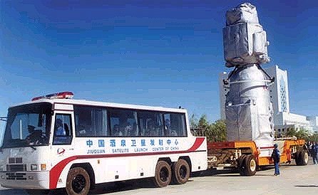
A
surprising picture
The somewhat surprising picture
below was shown on the Dragon
in Space Site. Transporting the spacecraft in the open - even if covered
by thermal blankets?? Well, I have some knowledge of the environment out
there. When we launched the Freja
scientific satellite from JSLC we measured the air quality. On ground
level on a windy day the particle count was 1 million (corresponding to
Class 1 000 000 in space parlance). On the top platform of the gantry tower
the same day we had a particle count of 1000 - i.e. clean room conditions.
The ground at JSLC is not not loose sand as on a beach, rather like a gravel
road. So, transporting the bird like this is not totally unrealistic!

 Back
to Space History Notes
Back
to Space History Notes