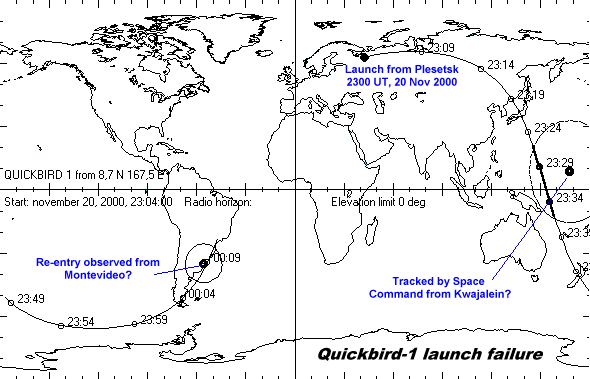
The object that Space Command tracked and called Quickbird passed over the horizon of the Kwajalein Atoll in the Pacific at about 2327-2335 UT. This is a place where the U.S. has many powerful radars Then there were no other sensors that could have tracked it before its assumed decay at about 0010-0015 UT. When it passed over Kwajalein (8.7 N, 167.5 E) its altitude (according to the element set published by NASA) was about 610 km. This was at the apogee of the transfer orbit, which had its perigee at the opposite equator crossing at an altitude near 80 km. The apogee near Australia was probably the point where the second stage would have fired again to circularize the orbit - well out of range of any Russian ground station. This has been standard procedure for Kosmos-3M launches. When circularizing the orbit of standard Parus navsats the second stage ignites again near the Antarctic.
So, it seems that the transfer orbit set up by the Kosmos-3M was correct. What then happened is difficult to know. The small difference in altitudes between the two orbital determinations may not be significant, i.e. they probably do not represent any change in orbit generated by an interrupted second stage burn.
The map shown here summarizes the flight of Quickbird-1. The visibility horizons at the two observations sites match the altitude at these occasions. The observation in Montevideo of a re-entry at about 0010 UT on 21 November, 2000 matches this flight path well.