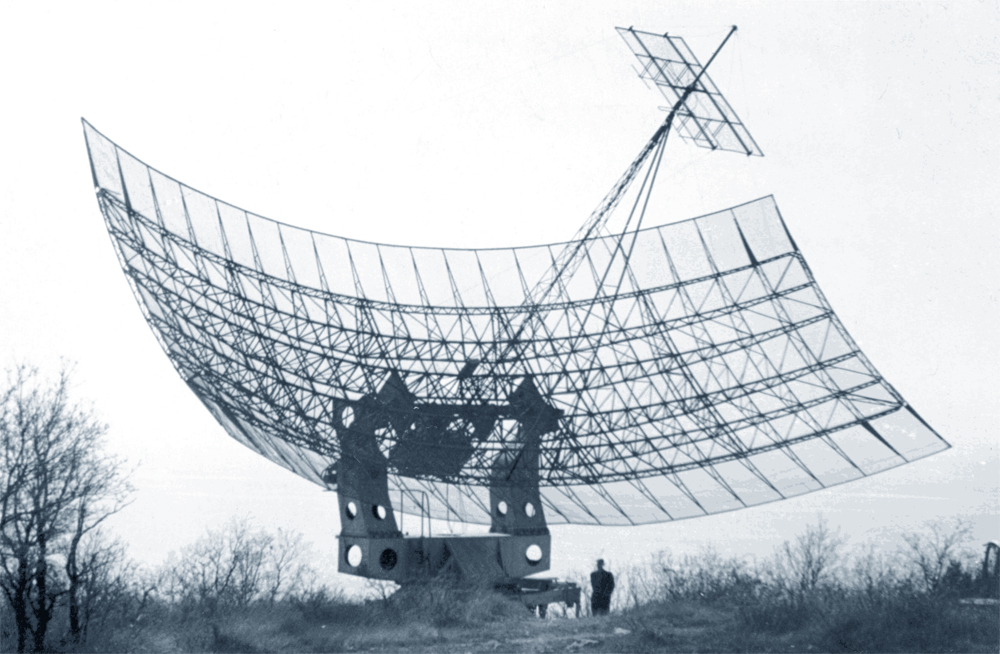
American radar SCR-627 on Cat Mountain.
(A
translation of https://www.kik-sssr.ru/41E_Simeiz.htm .
The translation has been made by Sven Grahn using
autotranslation tools)
In the middle of the 19th century,
even before the Crimean War of 1853-1856. in the Crimea a road was built, which
in the Soviet times became the Yalta-Sevastopol highway. Having existed for over
a century without major repairs (well-built then, however) in 1959 the track was
subjected to reconstruction. One of the first in the new asphalt passed military
vehicles with KUNGs to the Simeiz region. Many cars pulled trailers
...
If today we pass along the
Yalta-Sevastopol highway, then over Simeiz, where the road makes a small loop
between the northern and southern "parts" of Cat Mountain, at the southernmost
point of this loop one can see the exit to the road leading to the north. In 300
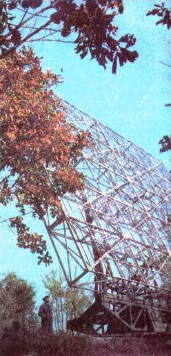
meters, still rusts, (but it lives!) a ten-meter tall structure, a place which,
in fact, will be in the museum. This antenna could take the world's first
photographs of the reverse side of the Moon ...
After experiencing the "wild"
times of the last decade of the 20th century (and as soon as it was not scrapped
during the general hobby of hunting for metals?), the construction may die today
simply from old age. Metal is also tired ...
Since 1949, the FIAN expedition was regularly sent to these places. The expedition was devoted to the radar of the Sun (the radio emission of the Sun was discovered by the British during the Second World War with the help of its radar tracking the approach of fascist bombers to the British shores: when the sun rose above the horizon, radio noise paths directed to the side of the antennas showed strong noises, disappearing with the disappearance of the Sun from the field of view of these antennas.)
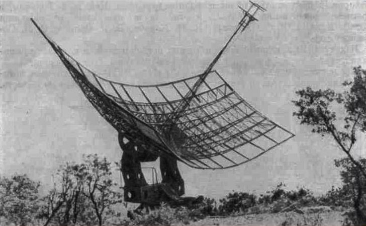
To ensure work on Cat Mountain, among the ancient burial dolmens and relict tree-like junipers, one of the American radar-SCR-627 obtained during the war with Lend-Lease was installed. It is interesting that according to Academician N.V. Karlova, who was a student at the Moscow State University, worked on the expedition, then this radar in 1949 was still secret ... (question: secret from whom?) Later, FIAN established in this place for the same purpose - radiolocation of the Sun-another antenna that still stands.
American radar SCR-627 on Cat
Mountain.
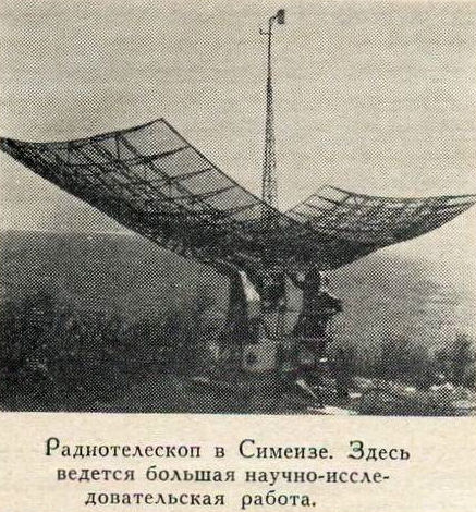
Its predecessor is an antenna of
the US SCR-627 radar mounted on Cat Mountain, with 72 dipoles, adapted by FIAN
scientists to study the Sun. (Interestingly, in the secret technical description
of the radar [in English], high-frequency connectors were officially called
"male" and "female.") You cannot exclude the fact that it took signals from
"Luna-3"
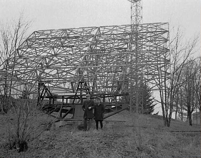
Chief Scientist at the LPI,
Professor R. L. Sorochenko: "In-phase Lattice antenna of the radar, which is
designed to detect aircraft appeared over the horizon, could only rotate in
azimuth. Radio telescope with such properties could not provide measurements of
refraction at different corners of the space. But P.D. Kalachev managed to find
a constructive solution, rotation of the antenna in elevation.
"
By the way, the same American
SRC-627 radar was installed in the late 50s and in the Far East - at the
Ussuriysk Station of the Sun Service (USSS, now the Ussuriysk Astrophysical
Observatory) and it operated there as a radio telescope at a wavelength of 1.42
m to 1987 - if you believe the Wikipedia and the history of the observatory:
"... the installation of a radio telescope on the basis of the station of the US
SCR-627, transferred by the FIAN to the country during the years of the
Lend-Lease War, was conducted.
The instrument for its solid dimensions and characteristic sounds during work was nicknamed the "dinosaur" and served the science regularly for almost three decades. In the photographs of 1978 below it is seen that the radar antenna in this observatory had not had dipoles for 10 years before 1987. But the turning device - exactly the same as in the Crimea.
In fairness, it should be noted
that the place on Cat Mountain is already at the turn of the 19th and 20th
centuries attracted observers for the sky. One local resident, with sufficient
money began to build a tower for the telescope, intending to conduct
astronomical observations as a hobby. Soon here from the Pulkovo Heights granted
and metropolitan astronomers, running from the fogs, slush and polluted by the
developing industry of St. Petersburg sky.
After the Great Patriotic War In
Crimea, there was another place where telescopes were located - in the foothills
of the Second Crimean Ridge, about 10 km from Bakhchisaray, the settlement of
Nauchny was founded. In this place, for the first time in the Crimea, radio
astronomy began to be studied.
The next "space" places in the
Crimea were the sites of the Crimean expedition of the FIAN: along with the
already "mountainous" Cat it was the sites on the Blue Bay beach in the village
of Katsiveli and in Alushta. It was in Katsiveli in 1953 that FIAN established
two mirror parabolic radio telescopes for the study of the Sun, which were
attracted by Academician Keldysh for solving some problems of the first Soviet
lunar program. The interference method developed by Professor V.V. Vitkevich,
allowed him to determine the angular coordinates of the spacecraft "Luna-1",
"Luna-2", "Luna-3" with the help of this pair of solar radio
telescopes.
|
|
The chief scientific officer of the Lebedev
Physics Institute, Professor R.L. Sorochenko: "In 1958, when the USSR launched a
program to launch space rockets to the moon, it became clear that only the radio
telescopes of the FIAN Crimean Station can provide reliable reception of the
information transmitted from the board and determine the flight
trajectory.
To the Crimean station came SP.
Korolyov, President of the USSR Academy of Sciences Keldysh and other senior
officials. The whole staff of the station and its instrumental potential were
connected to space activities. Based on 2 V-3 antennas, an interferometer with a
base of 175.9 m was created, with the help of which a flight path was determined
with a very high precision for that time (about 1
arc-min).
The exact location of the second Soviet space rocket landing,
reached the Moon on September 14, 1959, was determined exactly. "(I would not
have written about the place of" exactly the place of the landing "but would
have confined to the" area "- still at the angular dimensions of the Moon in the
sky in half a degree and the discreteness of measurements in 1/30 of the lunar
disk, it would be hardly possible to name the exact place ...). (A.D. Kuzmin.
Coordinate provision of first space flight to the Moon).
On October 4, 1957, the world's
first artificial Earth satellite was launched in our country. Soon the program
of flights of the world's first spacecraft to the Moon was launched. Missiles
suitable for this purpose have already been, and means for measuring and
controlling the trajectory of their flight at distances of tens and hundreds of
thousands of kilometers have not yet been created. Optical observations did not
provide reliability, primarily due to weather conditions. The radio-technical
means corresponding to the task in view have not yet been created. FIAN was
entrusted with the important and extremely difficult task of operational
measurement of the flight trajectories of spacecraft sent to the
moon.
In the container with scientific
equipment, a radio transmitter was installed, which made it possible to carry
out these measurements by radio methods.
The creation of the measuring
complex was to be completed in a very short time. The work, which received the
code "FAR" (very urgent work), was performed by a large team of radio
astronomers PRAO FIAN under the leadership of V.V. Vitkevich. R.L. Sorochenko
provided training antennas, VA. Udaltsov - the creation of radio receiving
equipment, L.I. Matveenko - the creation of a radiointerferometer. A.D. Kuzmin
was engaged in the ideology of the functioning of the system and the processing
of measurement results.
The work was controlled directly
by the "Main Theoretician" - the head of the space research program, the
President of the USSR Academy of Sciences, M.V. Keldysh and "Chief Designer" of
space technology. S.P. Korolyov..
The measuring complex was created
on the basis of radio-interferometers used in radio astronomy, which make it
possible to obtain the necessary measurement accuracy. Two large 22 x 11 meter
antennas were used in the Crimean FIAN Expedition, spaced to increase the
angular resolution by a distance of 176 meters in the direction of
east-west.
Measurements were made at the frequency of the on-board transmitter of a
spacecraft of 183.6 MHz corresponding to a wavelength of 1.63 m. To separate the
changes in signal intensity caused by a change in direction to the cosmic
apparatus and a change in the intensity of the radiation of the spacecraft
itself, a radio-interferometer with phase modulation was specially designed and
built.
A fundamentally complex element in
the creation of a measuring complex was the alignment of the antenna systems. In
the technique of antenna measurements, the alignment is performed over a
reference radio source, which uses a calibrated radio wave generator, with the
reference oscillator removed from the antenna by at least 2D2 / L,
where D is the antenna size (in this case the distance between the two
telescopes) and L is the working wavelength, and the coordinates its locations
are known. For an antenna system with a distance between its 176-meter antennas
operating at a wavelength of 1.63 m, the calibration generators must be at least
40 km from the antenna. In order for this generator to be visible from the
horizon, it must be raised to a height of several hundred
meters.
The flight to the moon was of
great scientific, technical and political importance and was provided with
everything necessary for its implementation. To raise the calibration generator
to the required altitude, a helicopter was assigned to work. To determine the
location of the helicopter, a special subdivision of surveyors equipped with
movie theodolites arrived, measuring and fixing the helicopter's location on the
film. However, the practical implementation of such a work, in which the flight
path of the helicopter was known only after the development and processing of
the film, with the need to temporarily link the location of the helicopter and
the calibrated system, could not ensure the fulfillment of the
task.
A.D. Kuzmin proposed and
implemented the use of natural cosmic sources of radio emission - the Crab
Nebula and the radio galaxies Swan-A and Virgo-A - for alignment as signal
sources. The location and trajectories of the motion of these objects on the
celestial sphere are known with high accuracy. The intensity of their radio
emission is also well known. Thus, this problem was solved, which, in turn, gave
rise to a new method of aligning and measuring the parameters of antennas by the
radio astronomy method.
The system of coordinate support
of space flights to the Moon has successfully worked on all three flights of the
world's first spacecraft to the Moon, Luna-1 (January 2-4), Luna-2 (September
12-14) and Luna-3 (4-6 October 1959). In real time, the trajectory coordinates
of the flight were measured. For the apparatus "Luna-2", which fell on the Moon,
the time and the region of the landing are determined. Selenographic coordinates
of the center of this region: latitude +30 deg. and longitude -3 deg. correspond
to the area of the crater Archimedes. It is interesting to note that the area
where this device hit the Moon crossed the circle defined by the British radio
astronomers at the Jodrell Bank Observatory from the Doppler measurements and
with the data of two Chilean monks about the dust cloud that they observed in
the telescope at the place where the spacecraft
fell.
This was the first experience of using radio astronomy methods of observation for solving navigation problems in space.
--------------------------------
Comments by Sven Grahn
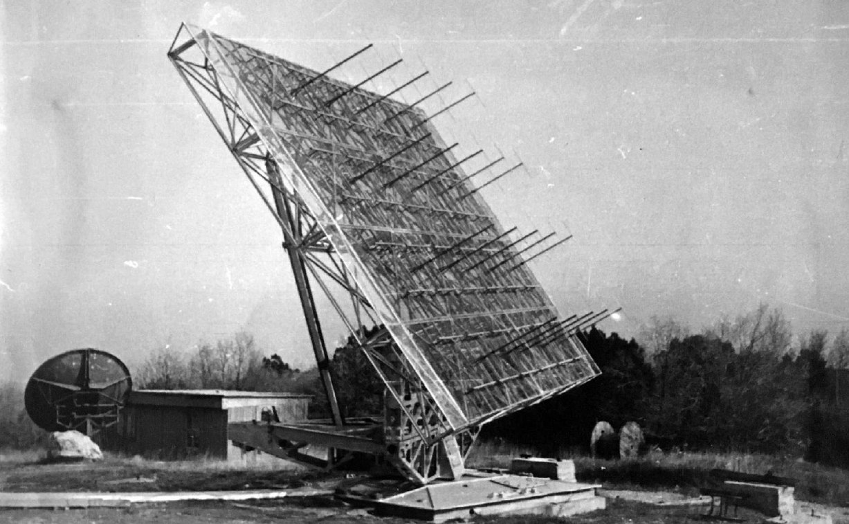
Here is a picture of the SCR-627 antenna from the operational documentation of the radar:
Here is an alternative picture of the SCR-627 on Cat Moutain published in early 2018.
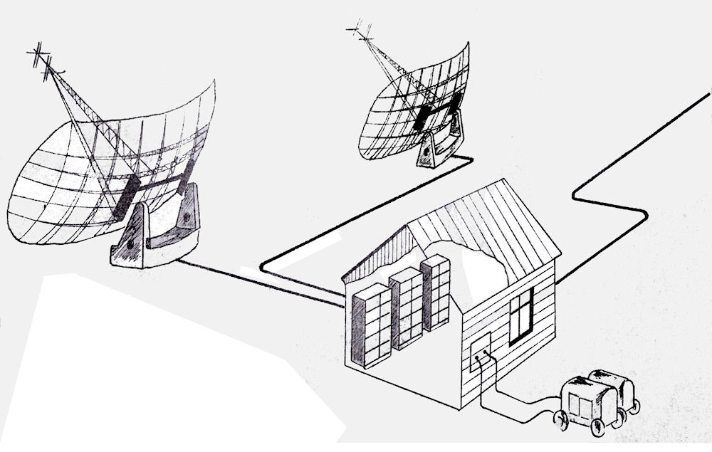
These are sketches of the station set-ups for
receiving telemetry (top) and providing angular tracking (bottom).
The
source is (http://russianspacesystems.ru/wp-content/uploads/2018/04/1958_NKU_BRK_Luna-2_Simeiz.pdf)

![]()